Sunday, October 28, 2012

The Unknown: Yoho National Park in the Canadian Rockies

Outstanding view heading into Yoho National Park in Canada
I had never heard of Yoho National Park until I started researching our trip to Canada. When I learned that Yoho is the Cree word for amazement, I knew we’d have to go there.

Located in British Columbia on the western slopes of the Rockies (Banff National Park, which borders Yoho to the east, is in the province of Alberta), Yoho is accessed by the Trans-Canada Highway. Created in 1886, it’s the smallest of the four contiguous national parks in the Canadian Rockies, but it can hold its own with breathtaking waterfalls, ice fields, lakes, and general ruggedness. For hearty outdoor enthusiasts, it offer fabulous hiking along the186-mile trail system.


One of the spiral tunnels that make rail travel safer and more accessible
Yoho is just 17 miles from Lake Louise, so we planned a day trip to hit the highlights that are accessible from the road. If you want to visit the area around Lake O’Hara, possibly hiking the shoreline or other lakes in the back country, you must take the shuttle bus on a road closed to the public. Visitors are limited in order to protect the natural resources, so reservations must be made months in advance. Since our time was limited, we opted to tour in our car and take shorter hikes to notable sights.
The first stop was at Spiral Tunnel Viewpoint and KickingHorse Pass National Historic Site. Spiral tunnels through the mountains were completed in 1909 and reduced the original railway grade of 4.5 percent (steepest of any railway in North America) to a safer 2.2 percent.

The Yoho River, fed by the Wapa Icefield to the north, flows through the narrow valley and converges with Kicking Horse River in a powerful splurge of waters coming from two separate cascades. Much of the park’s natural beauty has evolved from these rivers.

Takakkaw Falls is definitely magnificent.
When we turned off the Trans-Canada Highway onto Yoho Valley Road, the character of our sightseeing drive changed dramatically. This challenging road rises steeply from the valley with several tight switchbacks (no trailers allowed on the road).  It ends at Takakkaw Falls, the most impressive waterfall in the Canadian Rockies. Takakkaw, which means magnificent in Cree, roars 850 feet over a sheer rock wall at the upper edge of the Yoho Valley, creating a spray felt a hundred yards away. Walking to the base of the falls, the temperature dropped noticeably as we got closer, and the wind blew stronger. Multiple layers of water tumbled over rocks and cliffs , and folks who didn’t mind getting soaked could climb to a large rock outcropping for an excellent photo op.


Natural Bridge is an awesome sight
Yoho Valley Road took us back to the main highway and on towards Field, the only town with facilities and supplies in the park. Less than two miles west of Field we stopped for another intriguing sight—Natural Bridge. Here, Kicking Horse River has worn a narrow hole through limestone creating an arched bridge over rushing water. Eventually, the force will wear away the rock and create a waterfall. For now, it’s a worthy stop, just to admire the powerful water from the man-made overlook bridge. Still, we couldn’t resist walking –carefully—onto the rocky precipices for better photo opportunities of the mighty waterfall.

Emerald Lake is one of the prettiest in Canada.
After a brief stop at the Visitor Center in Field, we drove Emerald Lake Road to see stunning Emerald Lake while enjoying a late picnic lunch.  Surrounded by a spruce forest and tall mountain peaks, the lake was very crowded on Sunday—until a brief rain shower cleared out most visitors. Then it was truly peaceful and pretty, a wonderful place to walk along the shore admiring abundant flowers, mountain reflections, and sparkling water—attributes that make Yoho a popular park for those in the know.
Photos by Larry and Beverly Burmeier
 

Friday, October 19, 2012

On the road from Lake Louise to Jasper with stop at Columbia Icefield


Just outside Lake Louise, we saw this stunning reflection on Herbert Lake.
The drive from Lake Louise to Jasper in Banff National Park is only 188 miles, but plan for it to take all day. The reason: There are 13 viewpoints (and even more unmarked pull-outs) with magnificent lake and mountain landscapes along the way. You’ll need to keep your camera handy because it’s very obvious why the Icefields Parkway, otherwise known as Hwy. 93, is considered one of the world’s great mountain drives.

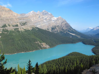
Peyto Lake's unusual shape has landed it on many postcards.
We were just a few miles out of Lake Louise when perfect reflections on Herbert Lake caught our attention, causing us to turn around for picture-taking. Then we stopped to photograph Crowfoot Glacier, a spot with lovely wildflowers blooming and elk wandering around. Bow Glacier was visible when we stopped by Bow Lake.
Peyto Lake, a lovely postcard-perfect destination, is recognized by its finger-like extensions at one end. A 10-minute walk on a paved trail led to the overlook where beautiful turquoise water is a reminder of the receding glacier that feeds the lake.

Glaciers abound, so we took plenty of photos.
Uplifts on mountain peaks are readily visible in the delineated strata. Fir, spruce, pine, and willow trees grow thickly along the roadside. Anemones, Indian paintbrushes, asters, and lupines are among the flower varieties we often saw. The day was sunny which made for stunning reflections on Waterfowl Lake and of different glaciers high up in the mountains.
The Ice Explorer takes guests onto Athabasca Glacier at the Columbia Icefield.
We arrived at the Columbia Icefield Center about noon and enjoyed an outdoor picnic lunch before taking the Ice Explorer Tour out onto Athabasca Glacier. After taking a bus to the base of Mount Wilcox, we boarded an Ice Explorer, one of only 22 in the world, for the 90-minute tour. Ice Explorers provide the safest way to tour a glacier, since the ice surface can be uneven, broken, or thin in places resulting in a potentially dangerous adventure. The vehicle waddles down a 32 degree grade from a dirt path onto the ice. Each vehicle has 10 huge tires, replaced every four year and kept at 15 psi in order to traverse the bumpy surface.

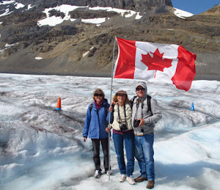
Posing with the Canadian flag during our glacier adventure.
Out on the glacier, we had almost half an hour to explore on our own. Warned about slippery ice, crevices and thin spots, we stepped lightly (although I did see one lady break through ice up to her shin—wet and cold). I filled Larry’s water bottle with glacial flow and climbed to the top of an ice hill to pose for pictures. It was hard to imagine that we were standing on 3,000 feet of ice. As with all glaciers in the area, Athabasca has been retreating since the 1880s (when statistics were first recorded). It’s possible to explore the Icefield area on your own, either on foot or by driving certain roads, but the Ice Explorer provided an incredible and unique experience.
Back at the Icefield Center, we visited the Glacier Gallery on the lower floor, with displays that told about glacier formation and movement. A large fiberglass model showed the entire Columbia Icefield and helped us gain perspective for Athabasca Glacier, Wilcox Mountain, Wilcox Pass, and this entire frozen environment. Also at the Center are a restaurant, snack bar, and limited hotel rooms at Glacier View Inn. The best thing about these options is the stupendous view on clear day.

Athabasca Falls near Jasper
After basking in the breathtaking scenery, we headed on to Jasper, with the Icefields Parkway paralleling Athabasca River. Twenty miles south of Jasper we stopped at Athabasca Falls. Here turbulent water cuts through boulders creating new paths in a narrow gorge.  Rock walls of the canyon are multi-hued and layered like ridges of stacked cardboard. Walkways lead to multiple viewpoints above and below the falls, each spectacular sight enticing us to keep clicking our cameras. Ten hours after beginning this incredible journey we arrived in Jasper.
Photos by Larry and Beverly Burmeier
Read more travel stories at Striped Pot and Austin Adventure Travel

Tuesday, October 9, 2012

Don't overlook Moraine Lake in Banff National Park

Understandably, Lake Louise in Canada’s Banff National Park gets a lot of the attention. It’s certainly worthy of the many photos taken and time spent strolling along its mile-long shoreline path--probably the busiest path in all of the Canadian Rockies.

 Clear turquoise water attracts visitors to Moraine Lake.
Even though you could spend hours soaking up the glorious mountain scenery and reflections at Lake Louise, don’t overlook Moraine Lake. Located eight miles from Lake Louise Drive, it’s too close to skip and too beautiful to leave off your vacation itinerary. There's also a lodge in case you decide you'd like to spend more time hiking and relaxing along Moraine's shores.

Canoeing on Moraine Lake's beautiful water with 10 mountains in the background
Set in the Valley of the Ten Peaks, Moraine Lake is surrounded by towering mountains, a source of inspiration ever since Walter Wilcox became the first white man to reach its shore in 1899.  The lake often remains frozen until June, but during our August visit it was spectacular. Moraine Lake was our chosen spot for a canoe adventure, a decision reinforced as we glided through clear turquoise water surrounded by stunning mountains. Paddling is easy to the end of the lake, where a small cascade spills into the main body of water.

Plan to take your time because you’ll want to stop and admire the mountains (all over 10,000 feet) and maybe even climb the rock pile that forms a barrier along the lake. Stepping carefully on floating logs, half submerged in the water, you’ll feel like a gymnast on a balance beam--until you reach the boulders. Then it’s a tough climb to the top--a challenge that goads on many visitors, children and adults alike. If you’re not careful, you might end up wet like the kids we saw fall off logs into the cold water. 

A trail follows the northern shore, and walking there is the easiest way to appreciate the beauty of this alpine lake. The flat trail weaves through shoreline trees and offers incredible views of the 10 peaks, including Tower of Babel, a mountain we especially enjoyed observing while canoeing on the lake. Scattered evergreen trees and an artist’s palate of colorful flowers--tall pink spikes, small white daisies, purple mountain asters, and more created an unforgettable lake and mountain scene.
Photos by Larry and Beverly Burmeier
Read more travel stories at Striped Pot and Austin Adventure Travel