Sunday, December 28, 2014

From Arequipa to Colca Canyon and the Highlands of Peru


Located in the southern part of Peru, Colca Canyon has become one of the country’s top adventure destinations. Day trips from Arequipa are the most popular way to see the canyons, and there are hundreds to choose from. Adventure and trekking tours are a big draw, but we’re headed to the Highlands of Peru to experience local culture, high-quality handicrafts, and spectacular .mountain and canyon scenery.
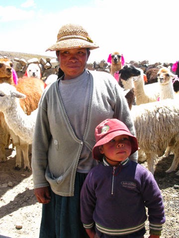
Tending to llamas in a remote area of Peru
We head towards Chivay, 100 miles from Arequipa, and Colca Canyon beyond that. We stop at a small corral with alpacas and llamas sporting colored ribbons in their ears that identify them according to age. We give candy to the young boy who tends the animals with his mother. In this isolated region, some children travel two hours each way to attend school, and tourists are rarely seen.

The Trans Oceanic Road that we drive on part of the day was built more than 20 years ago and runs from the Pacific to Atlantic Oceans. The landscape is mostly desert with only a few patches of green where onions and garlic are growing. Mountains in the background are composed of dirt and white volcanic ash that creates a haze drifting the air. Eventually we see more cacti and yellow grass that’s used to make roofs, sandals, rope, and bridges by the indigenous people.
The Trans Oceanic Highway travels through barren landscapes
and into the mountains of Peru.
Franklin, our driver, sets in for a long ride on this paved but desolate road with no place for comfort stops. Vicunas roam in the national park we pass through. These delicate tan and white animals, wild relatives of llamas and alpacas, have wool that is 25 times finer than human hair and much prized for weaving expensive garments. No wonder they are a protected species.

Vicunas graze in the shadow of majestic mountains.
As we approach higher elevations (now 12,300 feet) Beatrice, our guide, shows us how to roll up coca leaves and place them between teeth and cheek—where it stays for the next couple of hours. Sipping water makes our own coca tea, intended to counter effects of the high elevation (not a cure, by any means!).

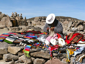
Locals offer a variety of goods for sale at roadside stops.
In the distance we see several volcanoes that were visible from Arequipa: Misti, Chachani, and Pichupichu. Mountains, lakes, and prairie landscapes flit by during our long day’s journey into the Highlands. While the terrain seems rather unfriendly, the native people are intrigued by U.S. visitors. This is not a tourist highway, so North Americans are not a common sight, especially at the higher elevations.

Along the way we encounter local vendors with handmade goods for purchase spread out on tables. Beautiful textiles and functional clothing items, as well as trinkets and souvenirs, are a modest means of supplementing their meager farming incomes. We stop for lunch and then continue our ascent into the mountains.

Photos by Larry and Beverly Burmeier

Friday, December 26, 2014

Say "Yes" to a Yurt

Antelope Yurt is comfortable yet remote, perfect for a
couple's getaway, yet close enough to Park City, Utah
for dinner and shopping. Blue Sky Ranch provides many
outdoor activities for guests.
 
Read my story about staying in a yurt at Blue Sky Ranch in Utah, published in NowU

https://www.nowu.com/article/travel/say-yes-to-a-yurt-and-find-serenity/19351085/

Tuesday, December 23, 2014

FAQs if you're uncertain about cruising


Today's ships are beautiful, comfortable, and safe.
Q: I’m not a “water” person, so why would I want to sail to different islands?

A: Sure, ships sail on water, but they go to many different places, not just islands. Think about Alaska, Europe, Africa, or New Zealand—none of which is visited primarily for beaches and water activities. You can explore famous cities of the world, delve into ancient history, marvel at mountains and glaciers, see fall foliage, or search for wildlife on cruises. If you like sand between your toes, there are plenty of opportunities to sunbathe, kayak, or snorkel at the beach.

Mountains and a glacial lake where we kayaked on
an excursion from our Alaska cruise

Q: Isn’t a cruise expensive?
Explore the Colosseum and wonders of ancient Rome.
A: Doesn’t have to be. Start with the base price, which can be very reasonable these days (we’re entering the “shoulder” season which has even more bargains). If you like to go all-out, dining in specialty restaurants and drinking fruity cocktails by the pool, your final tab will reflect that. But you can have a great time without going overboard. The cost of a cruise is generally less than a holiday at a resort—with entertainment, activities, and meals included. As for any vacation package, do some research to find a cruise that suits your preferred type of getaway.

Try rock wall climbing, miniature golf, ping
pong, golf, and many other activities on
the ship. Trivia and music are popular
indoor offerings..
Q: Will I get bored, especially when the ship is at sea?
A: A cruise ship is a massive floating resort with a wide range of places to explore and activities to participate in on board. You can decide last-minute to attend a nature talk or take salsa lessons. Play cards, jog on the promenade deck, work-out in the gym, get a massage, or just relax at indoor solariums. Quiet time in your cabin or on your balcony is a welcome option, too.

Q: Isn't a cruise all about the food?

 A: It’s really about choices. You can eat whatever and whenever you like. Cruise lines cater to guests who require special diets, so just ask for what you need, and you’ll be pleasantly surprised at the options available. Quality of the food has also improved considerably, with many ships offering flexible dining times and specialty restaurants in addition to standard dining. You decide whether to spruce up the wardrobe for a four-course dinner or find a quick buffet and dine in your sports clothes, Either way, enjoy the fact that someone else is cooking and cleaning up.
The food is delicious and well-presented.
Q: Don’t people get sick more on cruise ships?
Although a ship is a confined space where it’s easy for a virus to spread, most cruise lines take extra precautions to eliminate germs in public places. Hand sanitizer is available in dining venues as are constant reminders about cleanliness and washing your hands.

Relax by the pool, even if you don't put a toe in the water.
 Someships show movies by the pool at night.
As for motion sickness, today’s ships are very stable, so you probably won’t even realize you’re on a moving vessel in the middle of the ocean. If you do feel queasy, there are simple remedies that you can use prior to boarding and while on the cruise. And the ship’s doctors will help you through anything more significant. Over all, you’re no more likely to get sick on a ship than on shore.
 
Photos by Larry and Beverly Burmeier

Friday, December 19, 2014

What is the future of tourism in Cuba?


Mountainous landscape in Cuba; green, fertile valley is
prime land for agriculture
Almost two years ago, Larry and I participated in a people-to-people excursion to Cuba, one of the first that allowed U.S. citizens to visit the island country that has been off limits for more than half a century. We’re of a age to remember Cuba prior to Fidel Castro’s takeover in the 1960s and the horrors that people these have endured for many decades. So the opportunity to get an early, legal look at the previously-embargoed country was of great interest to me.
Americans currently may visit beaches on the southern shore
but not the finer resorts on the northern shore (since we're traveling
for cultural or educational purposes--not as tourists)
We traveled with International Expeditions, one of the U.S. companies licensed to bring Americans into Cuba. Itineraries had to pass Cuban discretion; and the Cuban government still determined which hotels we would stay at and where we were allowed to visit. We were not considered “tourists” and did not have the freedom to wander at our leisure; many areas were off-limits. Still it was an interesting and enlightening trip that I’m glad we took when we did.

Collecting and selling wild oranges
provides additional
income for poor Cuban farmers.
Now President Obama has announced that the U.S. is renewing diplomatic relations with Cuba. Travel is still limited, and we don’t know if restrictions will be lifted any time soon. Even though some of the educational and cultural visits have come under controversy (seems not all really accomplished the purpose under which they were licensed), it’s almost a given that the reins will continue to loosen. That goes for embargoed products, too.
The travel industry is now ramping up efforts to get permission to fly and sail to the island country. Travel companies expect a bonanza if Americans are allowed to travel as they wish, whether from curiosity or because Cuba has lovely beaches and mountains. Of course, at the present time, the infrastructure would have a hard time accommodating a large influx of tourists.
The tobacco industry is a mainstay of Cuban economy,
although cigars are still embargoed in the U.S.
How will increased tourism affect the average Cuban citizen? Will Cubans benefit with an improved standard of living, or will the government continue to control everything from salaries to what locals can buy and where and how they can travel?
Farm equipment is old and outdated like this tractor that is
still in use at a tobacco farm we visited. Russian parts keep
the tractor running--when those are available.
Since the U.S. is now negotiating with the Castro regime (Fidel, Raul, and their hand-picked successors), will the political repression ever end? Old-timers are not as enthusiastic about what the Obama administration is doing as are younger people who have no recollection of hardships the Cuban people have endured. Diplomacy can mean many things, but I don’t expect democracy to gain a foot-hold any time soon.

One of four main squares in Havana. Many of the buildings
are in severe disrepair, but new hotels are also
springing up. Increased tourism would require much more
than is currently available.
Visiting Cuba was eye-opening for me, a U.S. citizen. I can only hope that restoring diplomatic relations is the first step in actually rebuilding this historically important and naturally beautiful country. I can only hope this portends better times for everyone in Cuba, not just the privileged few.
Old and modern shops provide goods
for wealthier Cubans.
If you’re interested in getting in on historic changes, check out tours through the following organizations, which currently offer legal travel to Cuba:

Insight Cuba, 800-450-2822
National Geographic Expeditions, 888-966-8687

Common Ground Education and TravelServices, 412-203-1125
International Expeditions, 855-231-6866
Friendly Planet Travel, 888-555-5765

Cuba Education Tours 888-965-5647
Smithsonian Journeys, 855-330-1542
National Trust for Historic Preservation, 888-484-8785


Photos by Larry and Beverly Burmeier


Wednesday, December 17, 2014

Viewing volcanoes from the air on Hawaii's Big Island

I'm an admitted National Park geek, so on a trip to the Big Island of Hawaii, that was a must-see destination.

Since we’re staying on the drier western coast of Hawaii’s Big Island, we must drive across the island to Hilo for our tour of Hawaii Volcanoes National Park with Paradise Helicopters. When we leave, the topography along Hwy 19 is barren—a black lava landscape with occasional sprouts of brown fountain grass waving in the breeze.  
Red-hot lava deep in the crater
As the elevation increases from sea level to 2,000 feet, irrigated lawns and blossoming hibiscus are more common, although they look out of place still.  Eventually green hills line the background beyond the lava fields; and the landscape changes to palm trees, verdant valleys, even forested areas as we near the wetter eastern coast of the island.
Steam rises from the churning lava pits
We arrive at the Hilo International Airport and check in for our 11:30 tour. Maybe we’re crazy, but we choose the open door tour—50 minutes of flying above active volcanoes strapped into a whirling helicopter. with no doors to contain our bodies. We’re given waist-pack life jackets (thanks!) and earphones for communicating with the pilot and each other.
 
Another couple will fly with us, so passengers are loaded according to size. Being the smallest I’m directed to the center seat in front. The views are good, but I’m squished between the pilot and Larry, whose only constraint is a five-point harness. Needless to say, he holds on tightly to his camera.
No obstructions for Larry's photos

As we ascend to 2500 feet, we see fiery red lava spewing out of several holes in the ground. Flying over the countryside we see towns below and tall trees planted for wind protection.

Our pilot tells us that Hilo gets 196 inches of rain a year, while Mountain View—only five miles away—gets 298 inches of rain annually. That’s an incredible 100 inches difference in a very short space, but it explains the lush vegetation of the region.
Waterfalls flow into the river creating beautiful but
dangerous conditions for swimmers.
Around the volcanoes the landscape is steel gray, rocky, and pock-marked from previous explosions. In other places lava on the ground is layered like slabs of slate. After the eruption of 1969 blasted away the remaining road, everyone had to be evacuated from the steamy “shield” volcanoes. We marvel at all this from our bird's eye vantage point.

The helicopter that took us over the lava fields
A helicopter ride is an excellent way to see volcanic action in real time as well as remains from older lava flows. However, the rocky, desolate moon-like landscape changes as the Wailoa River and Wailuku River wind through state parks near Hilo.  From the helicopter, the contrast is vast, but it’s easy to understand the amazing attraction of opposites--fire and water--for visitors and locals.

Photos by Larry and Beverly Burmeier

Thursday, December 11, 2014

Plan your Africa trip to include the Great Migration


The annual migration of nearly 2 million wildebeest, zebras and gazelles through Tanzania and Kenya is a spectacle unlike any other. Called one of the "Seven New Wonders of the World," this event highlights movement of immense proportions for wildlife in Africa.
The plains are literally covered with migrating wildlife.
 A few summers ago Larry and I witnessed the Great Migration in early August as the animals journeyed from Tanzania into Kenya. The migration is reversed during the winter. Wildlife follows a predictable route, but the exact timing varies each year, depending on the start and severity of the dry season throughout eastern Africa.

Wildebeests and zebras typically spend December to April in Tanzania, nursing new calves born in the spring. The slow-moving calves draw the attention of lions, cheetahs and hyenas, and this mix of predator and prey offers prime wildlife-viewing opportunities in nature preserves like Serengeti National Park and the Ngorongoro Conservation Area home of the greatest concentration of mammalian predators in the world.
Wildebeests make up the majority of migrating wildlife.
Seasonal rains usually end in May. Grass and leaves begin wither, and to maintain their constant foraging, grazing species are forced to move west and then north in search of food. This is the start of the Great Migration, a steady stream of animals in columns that can stretch for many miles, heading toward the western and northern Serengeti.

Predators -- more territorial than migratory -- await the zebra and wildebeest as these animals pass through their hunting grounds. The migrating herds must cross the Grumeti River, where crocodiles will feast on the weak and the slow. Scavenging birds watch from treetops and circle overhead. June and July are typically the best months for witnessing the Great Migration in the western and northern Serengeti of Tanzania.

Zebras follow the wildebeests, further chomping down
grass that has been left as the wildebeests moved on.
As the summer progresses, the herds travel farther north. Between July and August, they cross the Mara River, where some are lost in surging floodwaters and others are seized by waiting crocs. They move into Kenya, typically reaching the abundant greenery of the Masai Mara in August or September, a dazzling number of animals within a single nature preserve.

Some naturalists claim that the Masai Mara contains the largest concentration of predators along the migratory route which makes it especially dangerous for the oldest and youngest of the species. We witnessed several examples of “the nature of things” during our visit. The animals stay there until October or November.
Not all of the wildebeests make it across the Mara
River; crocodiles are waiting for any that may falter.
Most safaris visit the area before fall brings another rainy season to the plains, and the herds turn south toward Tanzania. The animals that complete the journey will have traveled more than 1,800 miles, covering Africa's vast grasslands in a clockwise direction. Watching huge clouds of wildlife on the move, attempting to stay alive by finding new feeding grounds and evading predators, is truly a unique experience worth planning your Africa visit around.

Photos by Larry and Beverly Burmeier
Tuesday, December 9, 2014

Touring the Big Island of Hawaii and Hilton Waikoloa Village


It's all about water at Hilton Waikoloa Village
A tropical paradise awaited my first visit to the Big Island of Hawaii. We had booked a five-night stay at the Hilton Waikoloa Village, and after canceled and delayed flights on the front end, managed to get there for four of those nights. Although we arrived after dark, I immediately knew this resort was special, and we would have a magnificent Hawaiian holiday after all.
Hotel accommodations are spread throughout the 63-acre resort.
Located on the dry side of the island, volcanic activity is evident as soon as you leave the airport.  A two-lane highway is bordered by black lava and jagged boulders. People have created a form of graffiti using small white rocks placed on the black lava to spell out names and dates.

Once we entered the 63-acre resort, the landscape metamorphosed into brilliant gardens, swaying palm trees, and lovely ocean views—the quintessential Hawaiian vista. Resort amenities include five swimming pools, dozens of water features including fountains and bridges, dolphin pool, and gorgeous landscaping everywhere.
Sunset from Budda Point at Hilton Waikolao Village
You’ll get plenty of exercise walking on paved paths, but a shuttle train will also transport visitors around the property. Magnificent statues and artwork filled all areas of the resort. I especially enjoyed art pieces, many with an Asian influence, that decoraed long hallways. A variety of colorful (and sometimes squawking) birds added to the tropical ambience.

Take a helicopter ride to see lava fields.
Guests can dine at a variety of restaurants, from casual to upscale. A favorite was the Malolo Grill where we enjoyed dinner on a back patio by the light of table-side torches. A walk in the moonlight capped the romantic evening.  Sunset viewed with an appetizer of wine and cheese at Budda Point near the Ocean View Tower was another perfect moment. Most mornings we ate breakfast on our balcony; since our room was in the Ocean View Tower soothing rhythms of the ocean provided a relaxing start the day.
Active volcanoes on the Big Island still put out glowing, steamy lava
Our excursions included an exciting full-day tour to Hawaii Volcanoes National Park. Another day we drove to Hilo, on the lush, wet side of the island, for an open-door helicopter tour of the lava fields, a visit to Akaka Falls State Park, ziplining excursion with Skyline Eco Adventures, and a stop at Laupahoehoe Point Park for awesome views of waves crashing against the rugged shore.

Zip line near Hilo on the lush, humid side.
Golf at the Beach Course was fun but challenging because of a strong—but normal—wind. Beautiful views of the ocean made up for gusts blowing hair across my face.
One of the most spectacular sights on the Big Island is Waipio Lookout at Kukuihaele Park, about an hour north of the resort. The first evening we stopped there a huge cloud bank obscured the wavy coastline. Returning on a clear day we were rewarded with outstanding views of the coast and Waipio Valley.
Waipio means wavy coast


Then we headed south to the busy tourist town of Kona, a great place for a seafood lunch, walking along the shore, and shopping. I was struck by the huge contrast of drab, brown landscape on the drive there and the deep blue saturation of the ocean. We ventured out to Kahauu Beach near Keauhou Bay, south of Kona and waded in the rock-studded water.

Beach golf course overlooks the ocean.
Too soon it was time to leave the Big Island. But our next stop was Kauai, another perfect example of Hawaiian paradise.
Photos by Larry and Beverly Burmeier


Thursday, November 20, 2014

Lava flows continue in Hawaii Volcanoes National Park


After driving from the Big Island’s dry southeast shore through volcanic dunes, created when fine sand blown by trade winds piles up, we begin to appreciate the unique topography of this youngest and largest of the Hawaiian islands. Unlike Kauai, which has had millions of years to stabilize (no volcanic eruptions) and bloom into a tropical paradise, the Big Island of Hawaii continues to evolve.
Rising gases are a result of volcanic activity.
Five volcanoes make up the land mass of the Big Island. Kohala on the northern tip is the oldest; Mauna Kea at more than 13,000 feet is the tallest, and Mauna Loa is the largest by sheer volume. An active volcano, it erupts about every 25 to 50 years (last eruption was in 1984). Kilauea, home of legendary volcano goddess Pele, has been erupting continuously for more than 30 years with new lava flows that started in summer 2014 threatening to devour more roads and homes.

This landscape was recognized for its historic and geologic significance and became Hawaii Volcanoes National Park, the United States’ 13th national park, in 1916, even before Hawaii was a state. 

Our tour arrives at Jaggar Museum, and we observe glowing displays of red-hot lava in the crater there.  We walk steamy Sulfur Banks Trails filled with craters bubbling up strong- smelling sulfur dioxide gas. Then we drive the winding Chain of Craters Road where magma swells and forms a rift along which eruptions occur.  A 36-mile round-trip drive, Chain of Craters Road descends 3,700 feet to the coast and ends at a 2003 lava flow.

The volcanic rift is easily seen in this photo.
The caldera is easily accessible by car, which provides an excellent opportunity to see flowing lava. Since the lava’s path changes constantly, check with the Kilauea Visitor Center to get the latest report on where to see this.
Nate, our guide leads us to a remote area where we walk carefully on what resembles a moon scape, dusty and drab and jagged, to see the aftermath of the eruption of Mauna Ulu. Hills and small craters cover the area, and it’s very windy and chilly in late afternoon. But it’s such an unusual scene that we are glad to experience it. Spotty patches of vegetation creep in ridges as plant life adapts to this most improbable place. Even where it’s dry, the so-called fog drift provides much needed moisture.

Walking on a lava field
At sunset, Nate drives to his secret place where we dine in semi-darkness. He has planned a treat and invites us to follow him down a path, clutching flashlights and jackets against the night chill. Many tourists go to Jaggar Museum to witness what we see close-up in the dark sky--a brilliant red plume rising from the ground. We’re standing beside an active lava display, all the more spectacular for the darkness that surrounds us--—the crowning glory of our tour .
Vegetation is just beginning to appear after this lava
flow. No reconstruction has taken place here.
The gate to HawaiĘ»i Volcanoes National Park is open 24 hours every day. There is only one entrance to the park as the eruption from Kilauea from that began in 1983 blocked the other entrance. Since the eruption continues today, the road hasn’t been repaired leaving a 10-mile gap where vehicles cannot drive. 

Check on updates from the summer 2014 eruption. if you plan to visit

Photos by Larry and Beverly Burmeier


Sunday, November 16, 2014

Exploring volcanoes that shaped the geology of Hawaii's Big Island


Remnants of volcanic eruptions cover the landscape on the
Big Island's dry side.
We hear about volcanic eruptions in Hawaii and marvel at the fiery red molten lava that threatens to destroy homes and property. But the fact is that eruptions have been continuous for more than 35 years in Hawaii Volcanoes National Park on the Big Island. The thought is hard to comprehend until we start a tour from the dry, rocky side of the island to the more tropical and humid coast.
We meet few cars on Saddle Road (Hwy 200), a deserted span that cuts across the middle of island instead of following the coastline. Brown tufts of fountain grass pop up along the road with a few mesquite trees scattered around. The ground is covered with remnants of past volcanic activity.This is mostly ranch land with tradewinds blowing across the island that shake our van.


Vegetation begins to dot the barren land as we move closer
to the wetter, tropical side of the island.
The entire Hawaiian Island chain was created by volcanoes, which still fill the ocean for 18,000 feet below the surface. When there’s a hole in the earth’s crust, heat comes up from the mantle causing lava to dribble out rather than blasting the top off. The entire Big Island is a hot spot with a constant flow of lava in what is now the protected park.
As the youngest island in the chain, Hawaii is made up of five volcanoes that are constantly changing. Mauna Loa, an active volcano that last erupted in 1984, is the largest mountain in the world by volume. Even though only the tip is visible above water, it makes up 60 percent of the island.


Leaving Thurston Lava Tube, a massive lava cave.
As we enter the national park our guide explains that we’re going back to the birthplace of the islands. Our first stop is a lava tube, a cave-like structure that we can walk inside. In its natural state with rocks, dripping water, and slippery algae, we’re give flashlights to maneuver  through the dark.
Hiking on sharp lava. Some vegetation is creeping through
the solid rock.
Our guide explains that there are two types of lava—a smoother, spongy variety and craggy volcanic rock that is as sharp as a Brillo pad. At Huaka Crater we hike a bit off the beaten path and experience this type of lava—it sounds like walking on glass and can cut if you happen to fall on it. This deep crater contains rocks as large as automobiles at the bottom that were offered as gifts to Pele, volcano goddess to whom Hawaiians believe they owe the very existence of their island. We see a curiosity, a lava tree: Lava from the 1979 flow surrounded the trunk causing the tree to die but leaving a perfect, empty mold.


Deep craters like Huaka can be seen at several places in
Hawaii Volcanoes National Park.
I’ll describe more scenes from the park in a future article.
Photos by Larry and Beverly Burmeier

Thursday, November 6, 2014

Tips for staying healthy when traveling to high altitudes


If your vacation plans include hiking, biking, or fishing in mountains or a part of the world that is higher elevation than your normal home situation, be prepared for altitude sickness. With less oxygen in the air, symptoms of headache or dizziness may start to appear at about 8,000 feet elevation, although altitude or mountain sickness can occur even lower in susceptible people.
From Arequipa, Peru at 8,000 feet, we traveled into the Highlands.
Our guide kept telling us to move slowly and conserve energy.
Acute mountain sickness (AMS) is the most common type and causes symptoms similar to those caused by an alcohol hangover, usually within a day or so of arriving at a higher altitude. Symptoms may include headache, tiredness, lightheadedness, loss of appetite, trouble sleeping, and nausea.

For the 25 to 40 percent of people who get mild symptoms of acute mountain sickness, Dr. Eric Johnson, globally recognized expert on high-altitude medicine, says to rest and stay where you are until you feel better. “Do not  travel or climb to a higher altitude until all symptoms resolve.  Moving to a lower altitude can also help if symptoms do not go away in a day or two,” Johnson adds. 
Altitude sickness can occur in
summer or winter.
The good news, especially for people with limited vacation time, is that a common over-the-counter medication—ibuprofen—could help reduce the symptoms.  A study by the American College of Emergency Physicians reports that people who took ibuprofen before, during, and after an ascent were far less likely to develop symptoms of AMS.
“You don’t want to feel horrible for 15-20 percent of your vacation,” says Grant Lipman, MD, whose research at Stanford University corroborates the effect of ibuprofen.

More serious than acute mountain sickness are high altitude cerebral edema (HACE) and high altitude pulmonary edema (HAPE), both of which are less common but require descending to a lower altitude immediately. HACE involves swelling of the brain and results in trouble walking normally, extreme weakness, confusion, and/or irritability. HAPE involves fluid build-up in the lungs and may not show up for two to four days. Symptoms include coughing, feeling breathless, and trouble walking uphill. If symptoms are severe, get medical attention immediately.


Even at 18,000 feet elevation, vendors are selling their wares.
However, they are accustomed to lower oxygen levels in the air.
For any type of altitude sickness, breathing supplemental oxygen, if available, can provide quick relief. We’ve found that  hotel staff in high altitudes commonly supply oxygen in tanks for guests. Having experienced mild AMS myself, I know that this is often sufficient to relieve symptoms.
Prescription medications used under a doctor’s supervision can help prevent and treat mountain sickness.
Signs identified volcanoes that could be
seen from this high point. The air is definitely
thinner at 18,000 feet. 
Prevention is best, of course, so give your body time to adjust. Avoid moving quickly to high altitudes; plan to stretch out ascending over several days.  If you are hiking, biking, or climbing, avoid difficult physical activities for the first few days. When hiking to a higher altitude during the day, go back to a slightly lower altitude for sleep each night.  Skip alcohol and sleeping pills. Most likely your body will adjust if you allow enough time, so you can enjoy your travels.

Photos by Larry and Beverly Burmeier

Tuesday, October 28, 2014

Admiring Tom Mangelsen's Images of Nature


More than 15 years ago our family went skiing in Park City, Utah. As a neophyte on the slopes, I was happy to give my muscles a rest each evening while exploring the shops lining Main Street of this historic silver-mining town.
Main Street in Park City, Utah has many shopping and dining venues.
On one evening walk I discovered the incredible work of nature photographer Tom Mangelsen.

Mangelsen’s Images of Nature Gallery has been located on Park City's Historic Main Street for over 25 years, making it one of the oldest galleries there. Mangelsen’s work is also displayed in seven other galleries scattered across Midwest and Western states.
More than just a photographer, Mangelsen is a biologist by education and training with a commitment to conservation. He has traveled throughout the world for nearly 40 years observing and photographing places and animals. His scenic landscapes and wildlife images have earned many awards, including display at the Smithsonian Institution.

As a young boy observing geese and ducks on the Platte River of Nebraska, Mangelsen learned that patience was essential for photographing in the field. His understanding of animal behavior and willingness to wait for the unexpected moment have allowed him to create artistic images with his camera.

Without knowing anything about his background at the time, I fell in love with stunning images of his that captured the illusive moments of wild animal antics that photographers yearn for.
So, on a recent visit to Park City, I sought out his gallery to admire photos that captured my imagination many years before. Of course, Mangelsen has added many more from his travels, including several books that showcase some of his most prized and collectible prints.

The question for me was: Would I find an image so endearing that I would actually purchase an authentic, signed, limited edition print? Not surprisingly, the answer was yes. But there was an additional reason one particular photo spoke to me.
Mangelsen had photographed polar bears in Churchill,Canada several times over the years. Some of his photos of mama bears and cubs shot during spring excursions were on display and caught my eye--most likely because we had a trip to Churchill planned for the next month. What could be more enticing than a photo of the very bears we were journeying to see?

Now I’m the proud owner of a print called “Back Seat Driver,” which features a mother bear and her two cubs in the snow, one cub climbing onto her back for a ride. It’s adorable. But more than that it’s an image only a photographer with many years experience would likely capture. Even so, I’m hoping to add more of my own polar bear photos to the collection.
Photos from Beverly Burmeier, Mangelsen's web site, and ebay.