Saturday, May 28, 2016

Ride the rails through the Canadian Rockies, first day


The Rocky Mountaineer rounds a curve with vistas of
lake and mountains all around.
I’ve settled into my seat on the Rocky Mountaineer train when the hostess comes by with a warm, refreshing washcloth. Soon we’ll have breakfast, she says, as the train with a reputation for impeccable dining and service rolls by Eisenhower’s Peak and Castle Peak, mountains that preview scenery we’ll see on our two-day train ride from Banff in Alberta province to Vancouver on the western coast of Canada.
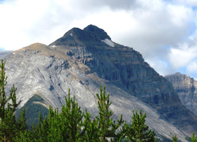
Majestic mountains provide scenic landscapes along the way.
Rocky Mountaineer began operating luxury trains in western Canada more than two decades ago. Larry and I are riding the most popular route called First Passage to the West, a journey through a vast territory of unspoiled wilderness that is not accessible by other means. As the only passenger rail service on the CanadianPacific track, it traces the rail route that connected British Columbia to Canada more than 125 years ago.

The route starts in Calgary, Alberta, travels 307 miles through breathtaking Rocky Mountain scenery around Banff and Lake Louise and then on to Kamloops in British Columbia, where passengers disembark for the night. Trains run only during daylight, so guests won’t miss any of Canada’s snow-capped peaks, gleaming lakes, and green river valleys along the way. From Kamloops the next day, we’ll ride 285 miles to Vancouver, arriving late afternoon.
Creating a rail route

Monument at Craigellachie
When the United States purchased Alaska in 1867, it was feared that British Columbia might be annexed by the U.S. British Columbia promised to become part of Canada in exchange for completion of a transcontinental railroad.
The Rocky Mountains have always been the biggest obstacle for establishing a southern transportation route across Canada because building through mountain passes was very costly. But the project was undertaken by Canada’s two prominent railroad companies, and the last spike was driven into the ground at Craigellachie (noted by a monument we pass) in 1895, ultimately uniting the country.
So many “wow” moments

About mid-morning we approach the Rocky Mountain Trench, a section of flat land that separates the Rockies from the Columbia Mountains. With those ranges and the Purcell Mountains in the background, we spend plenty of time in the vestibule, the open-air observation area between coaches. Although we have excellent views at our seats on the upper deck through a wide wall of windows that extends overhead, we feel more connected to the scenery when outside—and it’s the best spot for taking pictures.
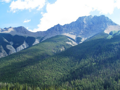
Rolling hills, mountains, and blue skies provide scenic views
on the Rocky Mountaineer train ride.
As the train travels through Mount Macdonald Tunnel, the hosts explain how avalanches in the 1880s often buried trains traveling over Rogers Pass. For about a century the Canadian Pacific Railway instituted various solutions, but in the 1980s CPR completed an engineering feat by tunneling through the mountain to create the longest train tunnel in North America. Each day 24 Canadian Pacific trains traverse its 10-mile length.

Large expanses of windows allow passengers to
enjoy passing scenery from the comfort of their seats.
Before daylight fades, the Rocky Mountaineer enters a semi-desert region. As we travel onto Thompson Plateau toward Kamloops, our destination for the night, the flatland is covered with scraggly sagebrush and rabbit bush vegetation. We learn that ranching and fur trading are important to the economy of Kamloops, whose central location has also made it a tournament capital for many sports.
Larry enjoys a cool drink
on the train.
While it’s possible to drive the distance faster, riding on a train is more scenic, comfortable, relaxing, and doesn’t require much more exertion than walking from our coach to the dining car. Since passengers spend the night in hotels, luggage is transported by truck and deposited in pre-arranged hotel rooms.

After our arrival in Kamloops, a bus takes us to Five Forty Hotel, where we find a lime green post-it note on our bathroom mirror that reads “Be a little crazy now and then.” Great advice, we decide!

Part 2 of Ride the Rails through the Canadian Rockies detail sthe second day’s journey and arrival in Vancouver. Read it here: http://www.goingonadventures.com/2016/06/continuing-train-journey-in-canada-on.html#.V1A99Cb2acw
Photos by Larry and Beverly Burmeier


Friday, May 27, 2016

Staying safe when boating

If water activities are in your vacation plans--anything that involves riding in a boat-- please read and heed these safety tips from the Sea Tow Foundation. Life jackets are especially important for children, but adults would do well to follow the  advice on this infographic. Stay safe to have fun!


Thursday, May 19, 2016

Traveling back roads? What to do if your car breaks down

Are you planning a road trip this summer? Even if you have your vehicle checked out thoroughly for any mechanical problems prior to leaving (really, a must), you should also be prepared in case you happen to get stranded on a lonely stretch of road with little or no cell phone service.

Especially if you like to venture off main highways and explore out-of-the-way roads and tiny towns, you should carry a paper road map to help locate where you are. Smartphones are wonderful for giving directions from one place to another or finding gas stations, tow trucks, or car dealerships in case of trouble. But your phone might not work as well as you need if you’re traveling on an isolated country road.
Driving the open road is fun--until trouble hits.
A red hazard warning triangle will alert other motorists if you have pulled to the side of the road, or if you can’t get the car off the road. In addition, or if you don’t have one of these, be sure to put your blinking emergency lights on. This makes your car more visible and will alert passing vehicles to the fact your car is not moving and that you might need assistance.
Hazard lights serve as warnings.

You can also hang a white cloth or piece of paper from the driver’s side window, scribble a sign to put in the rear window,  or tie a cloth on your car’s antenna as a signal for help. If you get out of the car to check on the problem, be sure not to stand or work on the car near the traffic side.

After dark, put on the interior light to signal the need for help. If the car’s engine will still run, turn it on periodically so you don’t run the battery down. If you get out of the car to flag down help, don’t block the hazard lights or stand in the path of oncoming traffic.
Should you stay with the car or seek help? The safest thing is stay with the car unless you recently passed something (a building, for example) where you might find assistance. If you’re certain help is within a reasonable walking distance, pull off the road and put a warning system into effect before leaving the vehicle.

Your main objective when stranded on the road is to remain visible while signaling your need for assistance. Even in the middle of nowhere, it’s possible either a stalled car or a driver wandering on the road may become victims of an accident because other drivers do not see them in time and realize their plight.
Photos from free sources.


Thursday, May 12, 2016

Affordable Kauai


Ruggedly awesome Na Pali coast of Kauai

Lush foliage in thick native forests and a proliferation of rainbow-hued blossoms surrounding streets and gardens are hallmarks of Kauai. No wonder this tropical paradise is called the Garden Isle of Hawaii. But it’s also called the Island of Discovery, an apt moniker because its geographic diversity provides options to discover landscapes as varied as sparkling beaches, mountains and valleys, forests and rivers, and soaring cliffs along the jagged coastline.
 
Kauai's Waimea Canyon is called the "Grand Canyon of Hawaii"
The oldest and fourth largest of the Hawaiian Islands, Kauai was formed from volcanic eruptions 5 million years ago. Thousands of years without eruptions have allowed the island to grow into a verdant haven with a unique topography among the islands. Its beauty is available for everyone to enjoy.


Blue waves sweep up on this black sand beach in Kauai
Visitors, whether first-time or repeat, continue to discover fascinating and free, or inexpensive, ways to appreciate Kauai. Enjoy these photos of my favorite Hawaiian island.

Beautiful beach on the north shore of Kauai

Opaeka Falls on Kauai
For the complete article, originally published in Arizona Highroads, March/April 2015, click http://highroads.az.aaa.com/article/kauai.

Photos by Larry and Beverly Burmeier
 

Monday, May 9, 2016

U.S. National Monuments worth visiting


The U.S. National Park Service celebrates its centennial in 2016, and there is much  publicity surrounding the  best known of our national treasures. While people are familiar with many of the 59 parks that NPS is charged with protecting and preserving, they may not realize that 112 official monuments also come under the auspices of NPS.
The monuments are all different, but each has a significant place in our country’s historic or scenic landscapes. In this post, I’m commemorating the centennial by highlighting a couple of my favorites.

The gigantic faces of Presidents Washington, Jefferson,
Teddy Roosevelt, and Lincoln greet visitors at Mount Rushmore.
Mount Rushmore National Memorial is an enormous sculpture carved into the granite face of Mount Rushmore in South Dakota. Nearly three million people visit each year. I visited there in July 2015 and marveled at the majestic presidential faces and the importance of each man in America’s history.
The Lincoln Memorial in
Washington D.C. shows a stoic
President who faced many challenges.
The Lincoln Memorial was built to honor the 16th President, Abraham Lincoln. Located on the National Mall in Washington D.C., the marble statue immortalized the president who preserved the country during the Civil War and became known as the Great Emancipator.

The Navajo National Monument, located on the Navajo Reservation in northern Arizona, preserves three intact cliff dwellings of the ancestral tribe called Anasazi. It honors the resourcefulness of our country’s early inhabitants, who learned to use what was available in nature to their benefit.
View from the rim of Cedar Breaks
in Utah
Cedar Breaks is a national amphitheater canyon with incredible rock formations similar to the hoodoos in Bryce Canyon National Park in Utah. The canyon stretches over three miles and is more than 2,000 feet deep with a hiking trail on the rim that provides exceptional views.

Grand Staircase-Escalante isn’t a single monument but almost two million acres of notable paleontological finds and stunning geology. The monument consists of the Grand Staircase, the Kaiparowits Plateau, and the Canyons of the Escalante—some of the most beautiful red rock landscapes in the nation and a stunning prelude to several national parks in Utah.
Driving in Grand Staircase-Escalante is a scenic journey
amid gloriously red cliffs
Mount St. Helens, located 96 miles south of Seattle, Washington in the Pacific Ring of Fire, is the most active volcano in the Cascade Range. Its most recent series of eruptions began in 1980 when a landslide and powerful explosive eruption created a large crater. It ended six years later after more than a dozen extrusions of lava built a dome.


You can drive along the rim of Colorado National Monument,
one of the grandest landscapes in the West.
Colorado National Monument is a gorgeous park near Grand Junction, Colorado. Spectacular canyons cut deep into sandstone formations in this area of desert land high on the Colorado Plateau. The park hosts a wide range of wildlife, and visitors can participate in hiking, horseback riding, road bicycling, and scenic drives. There are magnificent views from trails and the Rim Rock Drive, which winds along the plateau.
Waco Mammoth National Monument is among the newest, established July 2015 to protect a wooded site near the Bosque River on the north side of Waco,Texas where the remains of 24 Columbian mammoths were discovered in 1978. A short walk from the visitor center leads to the original fossil location where specimens from this mammoth nursery can still be seen.
See mammoth bones at this new national monument in Waco, Texas.
Photo by National Park Service
As you can see, even though these sites are called monuments, there’s often more than just one component, and many are just as beautiful and awe-inspiring as national parks. So what is the difference?

According to the National Parks blog: “The main difference is that National Parks are created through acts of Congress and must be large enough for broad use by the public. National Parks should have inspirational, educational and recreational value. National Monuments, on the other hand, are made through declarations from the President and have historic, prehistoric, or scientific interest.”

If you have a national park pass, it is good at any of the lands that NPS manages.
Photos by Larry and Beverly Burmeier


Friday, May 6, 2016

Cuba is the new adventure destination for American tourists

Curiosity drew us to Cuba in 2013. This island country lies just 90 miles from Florida's coastline, but it's a world away in culture and ideals. Cuba has been off-limits to American travelers for more than half a century, but some of the mystique has disappeared since the Obama administration pledged to renew diplomatic relations in January 2016.
Many Cubans have opened paladars, restaurants in their homes.
Read more about my journey in this article published in Arizona Highroads, a AAA magazine. We traveled 1100 miles across Cuba on a "people-to-people" tour with International Expeditions, learning how ordinary Cubans live and work every day.
http://highroads.az.aaa.com/article/cuban-culture

Children in a rural school accepted donations from our tour group.
Photos by Beverly Burmeier

Tuesday, May 3, 2016

LBJ Ranch celebrates park service centennial with bbq and music


The National Park Service and Friends of Lyndon B. Johnson National Historical Park will host a special barbecue and dance at the LBJ Ranch from 5:00 pm to 9:30 pm on Saturday, May 7, that will feature the Fort Griffin “Fandangle Sampler.”

 
President Johnson signed more national park legislation than any other chief executive in history—47 new park units were established and 23 were expanded. For that reason, it is very appropriate that Lyndon B. Johnson National Historical Park is the setting for numerous special events throughout the centennial year.
 
Aroma from The Salt Lick BBQ’s rotisserie will fill the oak grove on May 7 and the music of Jake Penrod and his Million Dollar Cowboys will keep guests dancing well into the evening. The night of entertainment and delicious barbecue will also be a celebration of the National Park Service’s centennial year.

Park guests will be able to experience a Fort Griffin Fandangle show very similar to the program that President and Mrs. Johnson first presented at their ranch in 1967 for ambassadors from Central and South American countries. The event on May 7 will be the fourth time a “Fandangle Sampler” has been staged at the LBJ Ranch—previous events were held in 1967, 1976, and 2008.

Each summer for more than seven decades the citizens of Albany, Texas have presented the Fandangle, the oldest outdoor musical program in Texas. It is theatrical history that is written, directed, and performed by hundreds of members of the Albany community. Through singing, dancing, and story-telling the Fandangle recaptures the history, folklore, and legend of the Old West.
 
Information and reservations are available at www.FriendsofLBJNationalPark.org . Reservations are $50 for adults, $15 for children 12 years and under. 

Lyndon B. Johnson National Historical Park is open seven days a week from 9:00 am to 5:00 pm. For a complete calendar of events go to http://www.nps.gov/lyjo/planyourvisit/calendar.htm

Information courtesy of Dave Schafer, LBJ National Historical Park
Photos by Larry and Beverly Burmeier