Sunday, December 27, 2020

True nature of Colorado Bend State Park in Texas

Towering rock canyons, more than 350 caves, and two spring-fed creeks make Colorado BendState Park near San Saba, Texas, a fabulous place to explore. With 16 miles of hiking trails, including 14 miles suitable for mountain biking, the park provides plenty of opportunities to enjoy unspoiled nature.

Go swimming in a beautiful spring-fed creek.

It’s about two hours’ drive from Austin (four hours from Dallas), making this a doable day trip or weekend getaway (both time and budget wise) if you’re visiting the Texas Hill Country. If you love the outdoors, the park is a great discovery filled with lush and scenic river trails and sparkling Gorman Falls.

 If the landscape isn’t enticing enough—and it certainly should be—there are multiple recreational opportunities. Whether your favorite outdoor activities include birding, fishing, hiking, picnicking, camping, or photography, you’ll find plenty to do at Colorado Bend State Park--just be sure to check on availability as long as COVID restrictions are in place.

Hike along the Colorado
River in the park.
Located along six miles of Colorado River frontage, Colorado Bend is a large state park, covering 5,328 acres. Partly because of its size, the intent is to keep it natural and easy to care for. Primitive tent camping is allowed in 38 numbered sites, and there are two backpack areas where guests can pitch tents. No electricity is available, but when serenity and peacefulness take over, you won’t miss it. Pets are allowed as long as they are kept on a leash no longer than six feet.

Originally an old Indian camp, the site near Gorman Falls is protected for archeological study. During the 1950s-1970s that area was a fishing camp and RV park. The state bought the land in 1984, adding more land from the former Lemons Ranch in 1987. These areas were combined and opened to the public as Colorado Bend State Park in 1988. Still, only 40,000 visitors per year journey the 18 miles from San Saba, through the tiny town of Bend, and over gravel roads to reach the park.

Native pecans, ferns, and cacti grow abundantly in the park, and wildflowers sprout up in the spring. Wildlife includes coyotes, bobcats, and mountain lions—although you probably won’t encounter these species. White-tail deer, armadillos, and squirrels are more common sights. You might also see wild turkeys, endangered golden-cheeked warblers, black-capped vireos, red-tailed hawks, and eagles (they nest on canyon walls).

Several geological features in the park are unique to this region. Spicewood Springs is a popular hiking trail with numerous creek crossings that leads to a refreshing water hole where visitors often come to picnic and swim. Painted rock formations, colored by different minerals seeping through, add to the beauty of this spot.
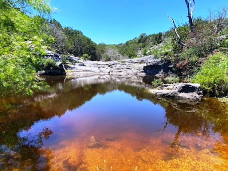
Springs along the trails add to the natural beauty of the park. 

Staff will take visitors on a two-hour guided tour to spectacular Gorman Falls on the western bank of the Colorado River, approximately 10 miles above Lake Buchanan (check that these tours are happening during the pandemic). Participants drive their own vehicles behind the guide for approximately seven miles from park headquarters. Then they hike to the base of the falls, a moderate one and a half mile round-trip that becomes slightly more difficult over rocky terrain the last 40-50 yards.

Gorman Falls is a highlight
of any visit to the park.

This impressive spring-fed 60-foot-high waterfall, tumbles over a cliff and mists ferns and other vegetation as it descends. Comprised of travertine, the top layers of calcium deposits are extremely fragile, so the area is protected. From the viewing deck, watch the flowing falls and then turn around to see the Colorado River meandering on the opposite side.  

You can also hike to Gorman Falls on your own, and guided cave tours are available during non-pandemic times. Outdoor enthusiasts are free to explore more trails and enjoy the park on its own primitive terms.

Some trails can be challenging, 
especially in hot Texas summers.

March and April are busy months--that’s prime time for white bass fishing and birding (214 species of birds have been identified in the park). Wildflowers start blooming in the spring, and the weather is fine for camping or hiking. There are so many ways to appreciate nature in Colorado Bend State Park that your first visit won’t be your last.

Photos by Larry and Beverly Burmeier


Sunday, December 20, 2020

What can a travel insurance policy do for you?

 During the past year we have heard much about the importance of travel insurance. Although it does add expense to your trip, it can reimburse you for many out-of-pocket expenses if you or a travel companion becomes ill or has an accident. 

Most policies also cover trip delay, trip interruption, lost baggage or baggage delay, flight delays, and much more. (Check for COVID coverage, as that may not be covered)

In addition, there are many services you might not be aware that having a travel insurance policy could
entitle you to. Need help planning your trip or booking guides and tours? Want to reserve a tee time at your destination or purchase tickets for a special event? Lost your eyeglasses or run out of a prescription and need a replacement? Many plans include a concierge service that can assist you with such things.


Although these are non-insurance services, knowing assistance is available can help make travel easier. The graphic below outlines some of the most common tasks that may be available to you through your policy. Make the most of what you've paid for! 


Information courtesy of Travel Insured International, a Crum & Forster Company. I do not receive any compensation from the company for posting this information.

Sunday, December 13, 2020

Hike Devil's Bridge in Sedona

Stunning red rock formations surrounding Sedona, Arizona are a calling card for visitors. You could hike a different trail every day for a month and still be impressed by the awesome beauty of the region.

Red limestone formations create amazing scenery around Sedona, Arizona

If you enjoy exploring on foot (yes, you can enjoy the scenery from a car, jeep, or helicopter too), one of the must-do hikes is Devil’sBridge Trail. It’s a moderate out-and-back trail just a 15-minute drive from town in the Coconino National Forest. If you access the trail via the most popular trailhead on Dry Creek Road, the hike will be a little more than four miles with an elevation gain of 400 feet.

Devil's Bridge as seen from the air.

One afternoon during our first visit to Sedona we took a helicopter ride to view well-known (and fondly named) sandstone rock formations just outside the city. We flew over Devil’s Bridge—and decided right then to go there as soon as we landed. That put us at the parking lot at mid-afternoon.

Our turn to take the hike

My advice: Go early in the morning when parking spots are still available. Because it was so crowded, our hike was a mile longer each way than it might have been. Jeeps and vehicles with four-wheel drive can venture part way on the rough dirt road, possibly cutting hiking time in half depending on where you are able to park. We walked the entire long and dusty route on Dry Creek Road.

The path is very rocky in places.

After about 1.3 miles (it seems much longer) you’ll see the path leading up the red cliffs to the bridge. The trail becomes rockier and steeper for almost another mile—scrambling over boulder is what makes the hike moderate rather than easy.

If you want to climb onto the bridge, take the right fork that leads to the top. It’s steep and a little more challenging, so Larry opted to stay where he was to take pictures of me as I walked over the bridge. He had a stunning view of the entire natural rock bridge, while I continued climbing to access the sandstone bridge from one end.

Beverly heads to the steep path that accesses the bridge.

The view from the top is breathtaking, but don’t forget to watch where you are walking. The bridge is very narrow at its midpoint, and the surface is uneven. It can be especially dangerous if wet from rain or a high wind is blowing. I don’t advise sitting down with feet dangling over the edge, as we saw one young boy doing.

Beverly walks on Devil's Bridge.

If you're not afraid of heights, it's a remarkable adventure that I recommend. Take enough time to soak in the outstanding landscape all around. 


View of the bridge from the opposite direction.

After you’ve admired views of surrounding red rock formations and tried to spot those you recognize by name, it’s time to scramble back down to Dry Creek Road and walk the rutted path back to the parking lot. To park, you'll need to purchase and display a Red Rock Pass for $5.

Allow about two hours for this popular hike, if for no other reason than to say you really did it!

Photos by Larry and Beverly Burmeiere

Sunday, December 6, 2020

Autumn hiking in Breckenridge, Colorado

Golden aspens glitter in the sunlight as we hike around Cataract Lake in Colorado. It’s late September, and aspen trees are reaching their peak of gorgeousness. Massive displays capture nature’s beauty while we repeatedly “ooh” and “ah” at the brilliant foliage displays.

Beautiful fall foliage set against majestic
mountains and blue skies in Breckenridge

One stop on this Colorado visit is to Breckenridge. With perfect blue skies and towering mountain peaks in the background, we think autumn is the most beautiful time of year here. It’s also a great time to take advantage of warm-weather activities like hiking, biking, golfing, and fishing.

Of course, when you plan a trip in advance, you can’t predict weather and fall foliage peaks, so we feel very lucky that our timing has worked out so well. Every place we visit around Breckenridge has proved spectacular, and the days have been mild and sunny.

Reflections along Sawmill Creek Trail

Breckenridge lies at the base of the Rocky Mountains in Summit County, Colorado. While its ski trails have made it a popular resort town for skiers in winter, outdoor enthusiasts can find plenty to do in any season of year. The only drawback for some people might be the elevation. The town sits just below 10,000 feet, which means oxygen levels are lower than at sea level. We find it necessary to slow our pace when hiking but otherwise seem to adjust okay.

Cataract Lake in the sunshine
Hikes most people can do

If you want to be outdoors enjoying the beauty of the area but don’t feel up to challenging mountain hike, here are a few that are doable for most activity levels.

Sawmill Creek Trail: This is an easily accessible mile and a half round trip trail that starts near the downtown Main Street shopping area. Parts of the trail can also be accessed directly from several condos in the vicinity. Aspens reflect in a lovely lake that we walk around.

As we return to the parking lot where our car is, we see the sign for Burro Trail, which is in White River National Forest, and decide to see where it goes. It’s another easy trek surrounded by autumn color. Go as far as you like then return on the same path, just as many local dog-walkers do.

Golden aspens all around the trail 


Cataract Lake:
Our original destination was Lily Pad Lake, but we find it closed when we arrive at the trailhead. Instead we hike Cataract Lake, about an hour’s drive north of Breckenridge. Located in the Eagles Wilderness area in the White River National Forest, this hike is now one of our favorites. Sunshine glowing through the aspens is simply spectacular as we walk a 2.3 mile loop around the lake. Spotting a bald eagle in a tree is a bonus.

On the way back to Breckenridge, we stop at Sapphire Point and take the 0.8 mile loop for scenic views of Lake Dillon, a favorite boating spot. It’s a nice place for a picnic and only about 8 miles north of Breckenridge.

View of Dillon Lake from Sapphire Point
McCullough Gulch: After a few days to acclimate to the high elevation, we decide to tackle a moderate hike (as opposed to easy hike). McCullough Gulch is 5.4 miles round trip. Since it is out-and-back, you can go as far as you want and then return along the same path. Be sure to drive two miles on the dirt McCullough Gulch Road/ No. 851to get closer to the gate and the entrance to the trail. 

Hiking on McCullough Gulch trail
This one is a little more challenging, and we find our walking sticks helpful for navigating over the uneven surface of large rocks and tree roots. Flowing streams, cascades, majestic mountain scenery, and more golden aspens make the hike worthwhile.

More outdoor options: Be sure to spend a little time walking along BlueLake within the town center. For more views drive eight miles south of Breckenridge to Blue Lakes Road/ No. 850 and park at the dam at Upper Blue Lake. From here you can view a waterfall, and you might even see some mountain goats. If you prefer exploring on two wheels, there are plenty of bike paths in and around Breckenridge--and rental businesses to outfit you with the proper style of bicycle for your adventures.

Photos by Larry and Beverly Burmeier

Sunday, November 29, 2020

Gateway to Mayan ruins


Entrance to Dzibilchaltun ruins near Progresso, Mexico

If you’re on a Western Caribbean cruise that docks at Progresso, Mexico, don’t miss an opportunity to visit Mayan ruins at the archaeological site of Dzibilchaltun. This is the oldest Mayan worship center among the 2,000 ruin sites that have been discovered from this ancient civilization (The oldest recorded Mayan date is August 13, 3114 B.C.)  If you’re on a family trip, Dzibilchaltun is an easy introduction to ancient history for school-age children. There’s plenty of room to roam and opportunities to physically explore structures.
Visitors can climb on structures like this Mayan ruin.

It was a major city for the early Maya with a population estimated at 200,000 people. Dziblilchaltun was still inhabited by the Maya when the Spanish arrived in the 1500s, and artifacts have been unearthed that date from 700-800 A.D. Its history and accessibility make it a worthwhile to visit.

Larry following two grandchildren up the steps.

Thirty-two narrow, uneven stone steps lead to the top of the main altar; other archaeological remnants include a large piazza and amphitheater. Temple of Seven Dolls is an imposing structure built on a pyramidal base. The doorways were built in exact solar alignment with the rising sun, so the rays marked planting and harvest seasons for corn, their main crop, which occur at the spring and fall equinoxes.
Precise location of doors and windows.

In this flat land, water filters through the soil and makes cenotes, underwater basins connected underground. These cenotes had spiritual meaning for Mayans, and visitors can explore some of the underground caves during the dry season of November-December.

Guides of Mayan descent, who are typically short and stocky, give an informative talk after which visitors can wander freely among the ruins for an hour or two. The structures are not prohibited here as for some other ruin sites.

Underground caves or cenotes can be explored during the dry season.

Located only a 30-minute bus ride from the end of the cruise ship pier (a long 4.6-mile man-made concrete structure), it’s a pleasant half-day excursion. Go there instead of taking seven hours to see Chichen Itza, where visitor activity is severely limited.
Looking through a window in one structure at other ruins

Beyond the Mayan ruins, the town of Progresso is a small fishing village, undistinguished except for the fact it’s the main port for Merida, a bustling modern city with more than a million people. Merida is the capital of the Yucatan, and Progresso provides the means for exporting and importing goods. Dzibilchaltun is about nine miles from Merida, close enough to visit both places the same day, whether you are on a cruise or traveling on your own.

Photos by Larry and Beverly Burmeier

Sunday, November 22, 2020

Explore America's Mountain

We saw it in the background driving into Colorado Springs, Colorado. We saw it through notched rocks when hiking in Garden of the Gods. We saw it and knew the mountain would have to be our next destination.

Just to prove you were there!
It’s almost impossible to view the grandeur of PikesPeak, elevation 14,115 feet, and not yearn to experience it firsthand. Fortunately, there’s a scenic highway to the top. 

Pikes Peak is called America’s Mountain because it is easily accessible with plenty of places to stop along the way, allowing visitors to enjoy the journey at their leisure.

The gateway to Pikes Peak Highway (7,800 feet elevation) is in Cascade, Colorado, just west of Colorado Springs. We wanted to be among the first to drive the 19-mile paved toll road to the summit, so we arrived before 8 a.m. Built in 1915, this winding road is the perfect scenic drive with views of lakes, mountains, wildlife, and an ever-changing landscape.

At about 9,160 feet elevation, we arrived at the North Slope Recreation Area, which includes fishing lakes, picnic areas, and hiking trails, as well as Crystal Reservoir, complete with gift shop. Because of our early start, the sun was perfectly positioned for us to witness sparkling, clear reflections in Crystal Lake—don’t miss it!

Reflections in Crystal Lake were outstanding.


The first six miles of the road was a teaser. The real start of the upwards climb to Pikes Peak began shortly after mile seven. That’s when the road became a succession of hairpin turns and switchbacks. We began to understand why driving 19 miles to the peak takes an hour or more.

As expected the scenery along the highway is truly spectacular. From the foothills, you ascend steadily through four of Colorado’s life zones. If you are observant you’ll notice changes in plants, animals, and climate when you stop at pull-outs along the way. Deer live in the Montane Zone, and wildflowers bloom profusely in the summer. In the Sub Alpine Zone, trees and plants must adapt to low water supplies and harsh weather conditions. The tree line stops in the Alpine Zone, and plants are sparse and short. If you are lucky you might see bighorn sheep wander across the highway.

Gotta pay attention on all those curves and switchbacks!

Because of construction of a new summit complex at the top, shuttle buses took most people from the 16-mile turnout. But we had requested to drive all the way ourselves and were lucky to be granted a pass—the better to experience all the mountain has to offer.

We made it! After the obligatory picture beside the Pikes Peak elevation sign, we headed into the Visitor Center to purchase their world-famous donuts. Served warm and crunchy, the donuts are made with special high-altitude ingredients.

Topography changes as you drive through various elevations.


Parking was hard to find because of all the construction vehicles and roped-off areas (hence the shuttle buses), but we still managed to spend a good bit of time wandering around and just soaking in the majesty of the views. The only problem was I left my puffy jacket in the car, and the temperature was in the low 40s. No matter, I trampled over large rocks and boulders and explored nooks and crannies as near to the edge as I dared.  And I took countless photos until my hands began to ache from the cold.

Spectacular views from the top of Pikes Peak

On the return, we stopped at Devils Playground at mile 16 and climbed more rocks until thunder warned of an impending storm (snow was expected that afternoon). Because lightening can be a severe danger at such altitudes, we decided to start the downward drive, putting the car in its lowest gear to navigate descending turns and switchbacks. At mile 13 (11,440 feet) there was a mandatory stop and temperature check to be sure brakes were not overheating. 

Wandering on rocks of Devil's
Playground, part of a hiking trail.

Things to consider: The temperature at the summit is usually 30 degrees colder than in the city, so bring a jacket even in summer. It’s possible to bike—or hike--both up and down Pikes Peak Highway, but it’s not a trip for novices. When driving, make sure your gas tank is more than half full as there are no service stations on the way. With speed limit at 25 mph or less, gas consumption is about twice the normal rate. The cog railway is currently undergoing renovation but should be in service for the 2021 season.

Photos by Larry and Beverly Burmeier


Tuesday, November 17, 2020

These books make great gifts


As the holiday season approaches, I have two excellent gift suggestions for different generations in your families. Both books can be purchased from Amazon, making shopping quick and easy!

Chicken Soup for the Soul, Age is Just a Number

First, I have a story in the new Chicken Soup for the Soul book, Age is Just a Number. The book is perfect inspiration for anyone who intends to live their best life after 60 (as I do!).  

My story, “Fulfilling a Dream,” recounts how I learned to fly on a trapeze long past the age most people would consider doing this. Here is a short video of my adventure: https://www.youtube.com/watch?v=5e16niZ2b5U&fbclid=IwAR1kACQnFf_xfzKht_VP46CCT-ZYc_2giK1rNt0icB51zZAqJkeWSreISfo

One hundred more stories prove that age shouldn’t be a factor when finding romance, traveling the world, starting a new job or business, learning new sports, overcoming fears, or finding new passions in life. There’s plenty of humor, too, as seniors tell about dealing with pesky technology, creaky joints, and those elusive thoughts that happen to all of us. Find the book here:

https://www.amazon.com/Chicken-Soup-Soul-Number-Stories/dp/161159071X#:~:text=OK-,Chicken%20Soup%20for%20the%20Soul%3A%20Age%20Is%20Just%20a%20Number,60%20Paperback%20%E2%80%93%20November%203%2C%20

Middle School Success


This book would be a great gift if you have a child or grandchild in middle school. Written by my grandson, Michael McGaugh II who is now a junior in high school, this guide can help students navigate a transitional (and often difficult) time in their school years.

Using his own experiences as the basis for tips and tricks, Michael has broken down 10 comprehensive steps to help make the middle school experience as stress free as possible. Each step addresses one aspect of school that can help students build success by getting the most out of their learning or simply keeping grades high. Find the book here:

https://www.amazon.com/Middle-School-Success-maximize-students/dp/B08MN7XSM7/ref=sr_1_3?dchild=1&keywords=Middle%20school%20success&qid=1605043333&sr=8-3&fbclid=IwAR2Br52qmZYaBQm3QpuwLo39FHUaz2ytM8v6FAjrSB4GY5PxzkhEvugJTyE

Happy reading!


Wednesday, November 11, 2020

Why the Maroon Bells are such a popular destination


We’re heading out of Aspen,Colorado to hike around the Maroon Bells, the most photographed peaks in North America.  But we’re not getting there as easily as we did 9 years ago.

It’s 2020, and the COVID pandemic has changed so many things. First of all, we did not make reservations before arriving in Aspen, something we could—and should—have done months ago when first planning our road trip. None of the sites I researched mentioned that fact, but for us this was a must-do.

So we had only one option: Drive to the check-in place in Snow Mass, arrive by 7:00 a.m. and put our names on a wait list in the hope that someone who did have a reservation would not show up that morning. That’s what we did. We were sixth on the list for the shuttle (parking passes were extremely hard to come by) that would take us nine more miles to the Maroon Bells site.

No snow has fallen yet in late September, but the temperature is 34 degrees as we wait outdoors for a possible chance to go. Finally, we get on the 9:15 shuttle (only 15 passengers allowed at a time), and in another 20 minutes we arrive at the Maroon Bells-Snowmass Wilderness Area. 


Vehicles are usually allowed to enter before 9:00 a.m. or after 5:00 p.m. During the day, visitors must take the bus from Aspen or the shuttle which conveniently drops you off at the base of the Maroon Bells, located in the White River National Forest. We disembark and follow the trail to Maroon Lake for our first view of the twin peaks.  Because of restrictions, the area is not as crowded as on our previous visit. Happily, that makes taking pictures without stray people much easier.


In the early morning sun, the view is stunning, and reflections are spectacular. The reddish tint of two 14,000-foot peaks contrasts beautifully with bright yellow aspens lining the slopes. With such an irresistible view we can’t stop taking so many pictures.

After walking around Maroon Lake and photographing the scene from different angles, we decide to hike to Crater Lake, just over four miles round trip.  The trail winds through an aspen forest and ascends 600 feet over rocky paths.  The initial incline is moderately difficult, partly because the altitude here is 9,000 feet, and the air has less oxygen.  And because we are almost a decade older, we find it more difficult than our previous hike there. But every bit as spectacular.

Golden-leafed aspens glow in the sunlight, draping the trail in luminous beauty. It’s an excellent fall foliage hike. At one point we look back to see Maroon Lake framed by a clear blue sky and colorful leaf display--a postcard-perfect scene. 


After an hour we arrive at CraterLake, which is surrounded by fallen logs and boggy ground, still a little crunchy from overnight frost.  The water level is low, but that’s normal for the fall season.  Snow melt in spring will fill up the lake again. The weather is surprisingly warm, and we shed layers of clothing, stuffing jackets in our backpacks until they won’t hold any more.  Because the air is dry, we must drink plenty of water.

Before leaving Crater Lake we find a log to sit on and refresh ourselves with some granola bars. A couple of chipmunks come scampering by. Larry puts his half-eaten snack in his backpack and wanders off to take photos.  It doesn’t take long for the chipmunks to find it, steal it away, and finish it off. A crowd of people gathers to watch the cute chipmunks--charming to everyone but Larry, who has lost the rest of his snack.


Upon returning to Maroon Lake, we pause for final views of the peaks. The sun has changed direction, and reflections aren’t nearly as sparkling and clear as earlier in the day. 

We board the shuttle for the ride back to our car and then drive back, arriving in Aspen around 4:00 p.m. Luckily, a local hamburger restaurant is just across the street from our resort, so we indulge in Larry’s favorite meal.

Photos by Larry and Beverly Burmeier


Wednesday, November 4, 2020

A volcanic detour

Having traveled to and through New Mexico numerous times over several decades, my husband Larry had often passed by a sign on US 87 touting Capulin Volcano. But he never stopped to check it out.

That’s where my curiosity comes in. I can’t pass up anything that is part of the National Park System. When I saw that Capulin Volcano is a National Monument, I knew we were about to take a detour.


Intriguing sign that piqued my interest

Actually it’s less than three miles from the main highway, a short drive on NM 325 (30 miles east of Raton on I-25). And well worth a visit.

Capulin Volcano is the result of an eruption 60,000 years ago. Glowing lava spewed high into the sky, solidified, and dropped back to Earth, accumulating around the vent or opening. The eruption produced volcanic rocks that formed Capulin into a cinder cone volcano.


 Early in the eruption, the first of four lava flows spread eastward from the cinder cone’s base. Later eruptions resulted in lava flows on the south, southwest, and west sides of the cone. Super-heated lava flows cooled while lava continued to flow underneath, resulting in interesting ridges that are perpendicular to the flow direction.

Capulin rises over 1,300 feet above the plains, 8,182 feet above sea level. As natural forces changed volcanic rock into soil, plants eventually took root. Prairie grasses, wildflowers, and pine trees began to proliferate. Since the volcano lies at the base of the Rocky Mountains, it straddles two very different habitats--the grassland of the plains and the forest of the mountains.

Lava flows extend on the plains
far beyond the cone.

In addition to getting information at the Visitor Center, you can actually walk on the volcano or venture into its crater. We walked the moderate one-mile loop called Crater Rim Trail. It was our first high altitude adventure on this trip, and we soon learned to go a little slower than our start. On the rim you have sweeping views of lava flows that extend far beyond the park boundary covering almost 16 square miles. If the day is really clear, you might be able to see New Mexico, Texas, Colorado, and Oklahoma from the rim trail’s highest point.

The volcano is extinct, so you’re probably safe descending 105 feet to the bottom of the crater on the short Crater Vent Trail. Or take an easy, paved 10-minute nature walk from the Visitor Center for close-up views of prairie landscape and lava formations.

To see rugged lava exposed, venture further on an unpaved one-mile loop called the Lava Flow Trail. Or try Boca Trail, a more strenuous two-mile unpaved loop that navigates lava flows and lakes, lava tubes, and a spatter hill.

Extensive views from the rim of Capulin Volcano

We spent an enjoyable hour traversing this symmetrical cinder volcano and observed nature’s recovery from the fiery eruption over many thousands of years. During our late September visit we saw the beginnings of fall color on the slopes; during spring, wildflowers create a lovely mosaic among the cinders. Picnicking and birding are also popular activities.

Thursday, October 29, 2020

What makes Austin, Texas like no place else?

Longtime Texans have an innate understanding of the uniqueness of their state--and Austin perfectly illustrates that mindset. If you're looking to visit a city that's a little out of the ordinary, here a few reasons why Austin should be your destination.

Flying Bats

People lined up on the Congress Avenue Bridge to await exodus of the bats.

Only in Austin would flying bats become a bona fide tourist attraction. From March through October hundreds of people gather every evening at dusk on and around the Congress Avenue Bridge to watch an enormous black cloud of millions of Mexican free-tailed bats stream out from crevices under the bridge and fly away for their nightly feast of mosquitoes and other insects.

Here they come! Millions of Mexican free-tail bats!

Keep Austin Weird


Drive around Austin, and you’ll see bumper stickers, T-shirts, and billboards proclaiming this unofficial city motto. It’s a sign of the quirky character Austin residents love and nurture. After all, the city created Spamarama, a festival that pays homage to canned meat, and Eeyore’s Birthday, a spring event honoring the sad-faced character from Winnie the Poo.

Live Music Capital of the World

On any given night, the sounds of blues, country, rock and roll, jazz, and folk blend in Austin’s famous music districts that attract patrons into 100 plus smoke-free establishments. The hip, college-age crowd generally drifts to boisterous Sixth Street, while the Warehouse District along Fourth Street attracts a supposedly more mature audience. You’re not an authentic Austin music junkie until you’ve joined ranks with hordes of attendees at South by Southwest or Austin City Limits Festival.

Armadillos and Deer

There’s a strange cult of armadillo lovers around Austin, to the extent that this armor-plated critter than neither hears nor sees very well has been adopted as a mascot.  Affection is evident in many things that bear this recurring symbol of whimsy: Art works, games, puzzles, toys, T-shirts, and jewelry contain the animal’s likeness. 


Austin’s science fiction convention has taken the name of ArmadilloCon. For more than 50 years residents have shopped the Armadillo Christmas Bazaar, which began as a special event at the famous Armadillo World Headquarters, once the hottest club in town and still a legend long after its demise.


The Hill Country

Austin is a gateway to one of the state’s best-kept secrets, the Hill Country of Central Texas. Northwest of the city is Lake Travis, a favorite recreational spot. 

With topography ranging from rocky ridges and gentle rolling hills to fertile ranch lands dissected by numerous rivers, creeks, and lakes, the region offers many surprises to outdoor enthusiasts. 

Spend a fun day boating on Lake Travis. 

Several state parks in the area, stunning scenery, fields of wildflowers (including bluebonnets, the state flower, in spring), and abundant wildlife bring city dwellers to the country year round.

Photos by Larry and Beverly Burmeier and from free sources.